Polish this turd as much as you want, it will still be cursed with douchebags across the globe. Me too, thanks.
Just another non issue. I can’t believe anyone other than cartographers really care. If you want accurate, get one of those blow up globes. Or most of the online mapping sites that turn into a globe when you zoom out far enough.
Kind of amazed that something I got told in RE when I was about 11 is true.
When did they mention map projections in Resident Evil? I don’t remember that part of the game…
Relative Earthanomics is a course taught in European gymnasiums. Obviously.
3D surfaces refuse to play well with 2D projections.
I’m going with the Gall–Peters Projection: https://youtu.be/vVX-PrBRtTY
I feel like I’ve been lied to even though I knew about the mercater projection.
It’s because you have been lied to.
Fair
This is going to piss off flat earthers. “What projection?”
uh-oh this will really trigger Trump’s size complex
Every few years this comes up again, and every time some nonsense about colonialism or whatever is brought up.
There is no “true” size or “true” shape on a 2D projection of Earth’s very 3D surface. We used the one projection for so long because of how coastal shapes don’t get bent way out of proportion, but like with any projection, messes with the other aspects.
Rather than making spicy click bait titles every so often about the “true” projection of the Earth, how about we teach kids at school what it takes to project something 3D on a 2D surface?
And just use a fucking globe!
For political uses new projection is better. UN body are not going to use that to navigate.
The only reason to have a default map is political.
People actually using maps and GIS pick whatever projection suits their needs - which is not Mercantor most of the time to begin with. I work with GIS a lot and never use it, unless forced by some API. But even then, reprojecting is trivial.
As a neurodivergent map person, I’m over-aware of the difficulties of map projection. And I agree that simply calling this new projection ‘accurate’ is misleading
But at the same time, the use of the Mercator as the standard default map in situations that have nothing to do with ocean navigation for literally hundreds of years is absolutely a reflection of the relative power of the Global North, and can’t be dismissed as ‘nonsense about colonialism’
What better alternative projection they could use at the time for navigation?
You might note that the present is, in fact, not 500 years ago.
Is that the answer to my question?
If you’re asking me to tell you the best way to navigate 500 years ago, I can’t help you because I’m not a historian. The point is that really has absolutely no bearing on how we should use maps today in the present.
And the present doesn’t affect the past.
from the perspective of an art conservationist i’m not entirely sure i agree.
I don’t know? That’s not what we’re talking about. We’re talking about the UN using it not for navigation in 2026
But at the same time, the use of the Mercator as the standard default map in situations that have nothing to do with ocean navigation for literally hundreds of years
My question continues that thread.
And my point (subtle it may be) is that when something is wildly useful, it sticks.
Despite not being universally good.And to change from it you need more than just a slight advantage.
That’s why the UN didn’t think about changing map projection.
It is complete nonsense. Use makes something standard, and maps have most been used in navigation. So it naturally becomes the default.
This is how ALL defaults become defaults, even when they’re wrong.
You know it’s the Reverse Mercator right?
It’s been the best way to transform a curved surface to a plane surface in a way that people understand.
It’s not the Reverse Mercator… I’m not sure what that is
Do you mean Transverse Mercator? Although it’s not that either
Yeah I did, thank you
Edit: and yeah we definitely use the transverse
(Well, we do sometimes but it’s not the map in question)
The link you provide says we use the Transverse Mercator projection
I screwed up with ‘reverse’ but it was transverse I meant and it’s what’s popularly used.
Exactly. It’s easy to brush off the idea of soft power but it has real consequences.
The Mercator projection really seems to be Africa-centric if anything
In what way? It inflates the size of areas as they get further away from the equator, resulting in Africa being portrayed as relatively much smaller than it is compared to Europe and North America
Africa is by far the most accurately portrayed part of the map, and it’s right in the center.
Now I’m imagining a dick measuring contest where the men care more about whose is measured most accurately for some reason, rather than showing off how long their dick is
The center - east to west - is 0 degrees longitude, defined as the Royal Observatory in Greenwich, England. This does also go through West Africa
The center - north to south - is 0 degrees latitude, defined as the equator.
Because of this, Africa is central on the vast majority of world map projections including the Mercator and the Equal Earth.
Accuracy is relative. The Mercator distorts areas bigger the further away they are from the equator. This exaggerates the size of the USA, Europe etc compared to Africa.
it’s in the center?
so coming from you pleasr tell us what would be the best way to project an as accurate as possible world map? I mena both in 3D version and as a 2D version
A 3D version would be a globe. A 2D version is inherently inaccurate because it’s 2D and the earth is not. You are free to pick your poison in the manner of your projection but you will always loose something.
So when it comes to picking a 2D poison which ome would be currently best? The new UN map ? or …
Or would a better solution for 2D be a ‘collection’ of pictures of the Earth from numerous different angles? And we just look at each of the angles seperately as their own seperate 2D picture of different parts of the Earth? So Im talking we supposedly take 14 or 20 or more different pictures of the Earth from 14 or 20 or more different angles of the Earth then we just lay out each of those pictures and it is up to the viewer to look at each picture of each angles of the Earth and to do what they can in their head with those pictures. Bad idea, good idea?
Pick one that suits your application.
If you’re not using it to engage in navigation, Equal Earth is a sensible default.
Tools like Google maps are a bit thornier. They’re used for navigation, but generally not in a way where angles matter. I could see someone getting themselves into trouble because the angles are screwy. But then again if Google cared about that sort of case, we wouldn’t have the recent story of the Gemini hikers.
That is not really an answer.
What is the best general world map to teach kids about the world, that we can put in a book or as a poster on the wall, without having to switch to different maps for each lessen, confusing everyone?
If it is not Mercator, then which one is?
For teaching kids Equal Earth is a reasonable choice. Scale and relative global position are conveyed better.
A side effect of Mercator massively distorting size near the poles, neither Europe nor Canada don’t feel as North as they actually are.
Kids don’t have much of a reason to care about specific angles.
I mean, before the advent of GPS, ships at sea got a “fix” of their position by taking two measurements: north/south latitude (via a sextant when the sun was visible) and east/west longitude (via a set of very accurate clocks that showed the time in Greenwich England, which could be easily compared to the time aboard ship). Mercator maps are just a grid showing where all the land is as a function of these two measurements on the X and Y axes. Any other projection would have just meant a lot more work figuring out where shit was, which is why Mercator became “the” map. It had absolutely nothing to do with any attempt to make Europe appear dominant – Europe’s dominance when these maps came into existence was too obvious and unquestioned to need any parlor tricks.
Isn’t this incorrect though? As far as I am aware it is possible to represent true size (equal-area) or true shape (conformal), but not both at the same time
Yeah, isn’t that what I said?
I read it as neither one is possible, but maybe it’s on me.
Well, I meant is when projecting something in 2D, you’re making a sacrifice somewhere.
How do you use a globe on paper tho?
Clearly we need to invent globe shaped books.
some nonsense about colonialism or whatever
Wow imagine believing this nonsense. Privileged “or whatever” AF. Why do you think USA voted against this? Ofc it’s racist and colonial.
Then there is the politics. The United States voted against the resolution, insisting it was a distraction. But American resistance actually strengthens the argument of those who voted to change the map. If the map does not matter, why oppose it? If size does not matter, why insist on preserving the projection that makes the US appear larger? …
Moky Makura of Africa No Filter put it more sharply: “If we got something as basic as Africa’s size wrong for this long, what else about Africa have we simply accepted without questioning? Africa doesn’t need to be made bigger. It needs to be seen accurately.” …
The geopolitical implications of this generational shift should not be underestimated. The Mercator projection did not merely distort geography; it distorted ambition. For centuries, European and American leaders made decisions about Africa based on a visual representation that made the continent look insignificant. That misperception shaped colonial borders, investment decisions and strategic calculations. The Equal Earth projection will not erase that history, but ultimately, it will reshape how future leaders, African and non-African alike, conceive of the continent…
Dr Ikenna is right that the science of map projections is technical and trade-offs are unavoidable. But the politics of representation is not technical. It is about how people see the world and, more importantly, how they see themselves in it. Friday’s vote was not about changing geography. It was about changing perception. And perception, as every cartographer knows, is the map that matters most. - https://www.thecable.ng/the-mercator-myth-how-a-map-shaped-the-worlds-view-of-africa/
I don’t really understand the difference, but Greenland is not bigger than Australia right?
No
Think of opening the earth up onto a cylinder and stretching it out and over its surface, then flattening that cylinder out.
It will be equal in the centre, but distorted at the ends.
The projection we use is the Reverse Mercator, as its ‘cylinder’ sits vertical so to speak, distorting the poles. Horizontally, it would distort across the Equator in a couple places, which wouldn’t be useable.
The projection we use is just the Mercator. Horizontally, it’s called a Transverse Mercator
wait. is yo mamma fatter in greenland or NZ? what if we remove NZ from the map?
I’m kinda surprised there weren’t tons of countries against this. For its faults in representing size the Mercator projection is great at representing direction (that’s what it was intended for after all). For Japan, New Zealand, and even Austrailia this places North at really awkward angles, making what are in reality straight lines appear curved. If anything, this is even more euro centric than the Mercator projection due to the amount of straight line distortion applied being longitude dependent, centered around Europe. I’d also expect Russia to be against it since it makes them look smaller, even if they don’t have the same distortion problem as countries directly opposite Western Europe.
making what are in reality straight lines appear curved.
Totally unheard of before.

The projection should have been changed, but it should be a a compromise projection like Robinson or Winkel Tripel that doesn’t perfectly preserve area, distance, shape, or direction, but also doesn’t horribly distort any of them.
Hahaha, Russia 🤏
This is true proportional/scales size. I’m sure Russia is bigger than an inch wide as it’s displayed on my screen
pff. that’s tankie revisionist current eventstory
I’m sure Russia is bigger than an inch wide
That’s just what the US Military Industrial Complex want you to believe!
The title falsly implies that mercator is “incorrect”. Mercator is an angle preserving projection, meaning all angles are true to real life. The “equal earth” map is an area preserving projection, meaning it retains the true area of countries, but in return the angles are all wrong. This makes equal earth unsuitable for navigation for example.
It is also wrong to imply that this is some kind of new development. This was very much known all along, mercator simply became the default because world maps used to be primarily for navigation.
We had some cartography classes in the university and since then I cant accept anything other than 3D globe or parts of it.
I don’t fly an airplane or sail a ship to need straight lines.
Yes, all of the 2D projections distort too much. When possible, half of the globe should be shown, from whichever angle is most relevant. Many people have no idea what a map centered on the North Pole looks like, and how close the countries in the northern hemisphere are to each other.
how is Canada smaller than the USA in this “equal earth” map when it’s supposed to display true areas? or is the pic in this post just shitty?
They’re about the same size. In this image, Canada’s northern islands are all spread out to show them inside their Mercator projections. You have to mentally add them to the large mass.
They look about the same size to me and they should be about the same size. So that checks out.
Canada (without the various arctic islands) is considerably smaller than the contiguous (sans Alaska and Hawaii) US.
Mercator projection is Canada’s pushup bra.
We’re repeatedly told in school and all throughout our media that Canada is the “second largest land mass in the world”. Is that not true?
Land mass or country? Because the Americas make us the second largest land mass with Eurasia and Africa because the largest.
Isn’t Africa connected to Eurasia? So we have the Americas and AfroEurasia plus some islands. Which is why “continents” has no meaning and is another social construct unless you divide them in a way that makes zero sense to anyone who isn’t a geologist.
Which is exactly why I said Eurasia AND Africa. I also never said continent. I said LND MASS which is what was previously said.
Work on your reading comprehension.
We should divide the continents in:
Continents: the actual land, so we have the Americas (i’d count them as one as they are almost one), AfroEuroAsia
Sub continents: their definition is cultural so we have north and south america, Africa, Europe, Asia and Oceania
Don’t take anything too seriously, i thought about this on two feets around 2 years ago and forgot about that until now
I know at the end of the day it doesn’t really matter, but it always rubbed me the wrong way when Europeans claim that The Americas are one continent because it’s one connected landmass, but somehow Europe is it’s own continent. North/South America at least came from different super continents and only recently collided. Europe (minus the Balkans) and Asia (minus Arabian and Indian peninsulas) have been together since at least Pangaea.
Canada is the second largest country in the world by area.
It’s bigger even if you include Alaska (and Hawaii, but you can ignore Hawaii because it’s small).
Because Canada is ~10% smaller than the US.
Smaller in area?
According to wikipedia, these are the total areas of both countries:
USA: 9,833,520 km2 Canada: 9,984,670 km2
I am certain I am just misunderstanding the system behind this new projection but reading it is supposed to display accurate area, it seems Canada should show up bigger.
You have to look at the land area.
And lakes and rivers those count too
And that, folks, is why map projections matter, and this update is loooooong overdue.
Canada is slightly larger than the US in total area. The US is a tiny bit larger when you just count land-area.
Well yes, Canada is larger if you count the ocean as part of Canada lmao
You say that but do you count Hudson Bay?
Per population density, Canada is a 50 mile stripe along the US border.
Canada total area: 9,984,670 km^2
USA total area: 9,866,624 km^2
Have a look a the respective 2nd digits of those numbers and consider that 9 is indeed bigger than 8.
Source: Wikipedia.
Total land area: 9,093,507
You are counting ocean as part of Canada, a thing not represented on maps.
Imagine being this condescending and wrong.
No oceans were counted. But the total area does includes lakes and rivers.
And I already said earlier that the US slightly larger when you just look at land area. It’s no where near 10% though.
Imagine being this condescending and wrong
You’re the one doing it
This post is a perfect example of why we need the new map, lol
Traditional navigation is so cool, I had to learn the basics of it a few years ago as part of a course I was on. I suspect it’ll feel rather less ceremonial in the future if GPS jamming and spoofing continue to become more common.
Did you know intercontinental missiles navigate with the stars? :o
They navigate by the stars, and then briefly turn into one.
The title is incomplete, but then again the title is already pretty big without being “The UN has backed replacing the 500-year-old Mercator projection with maps that conform to the actual surface areas of the continents, including the Equal Earth cartographic projection, were appropriate”
What is new is that we now for sure know that it impacts perception of how important a country is. So it is quite new, and Mercator is very much “incorrect” for the purposes of a representative map of earth.
This is a good and long coming change.
Reminder that the red depiction is also “wrong”, and not the equal area projection. The equal area projection map looks like this:
(Can’t upload pictures on blahaj piefed, HTTP 400 error)
In some senses, the red area is more wrong than the Mercator, since it is not a projection at all, but a false projection. The distances between the countries are misleading, especially when superimposed on the Mercator, which is also misleading in terms of sizes, but not shape.
All projections are compromises, but false projections are completely untethered from a mathematical relationship to the actual globe.
It is OK and not misleading if it were made clear that the red area is NOT a map, but a way of depicting the size only. Since it is shown in a geographic context with no disclaimer, i don’t think this is universally apparent.
Here is a link to a 3D globe: https://tembrica.com/en/earth-globe
Here is a good comparator of Mercator size vs equal size countries, not superimposed on a map. https://www.runcell.dev/tool/true-size-map/equal-earth-projection
Equal Area projection:

@time2lose@lemmy.world update your post with the correct image.
There are many equal area world map projections, this one is called Equal Earth. It’s a very solid choice too. Although the very top and bottom of this map are still stretched when viewed on a Tissot indicatrix. Still way better than the shitty Mercator.
Why is the Mercator shitty? It has its purpose and it’s good in it.
It’s great for countries in the middle, I.e Europe. Everyone else gets warped and slanted to the side.
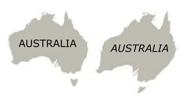
Gonna have to rename ourselves to Australia.
Don’t you mean: ɐılɐɹʇsn∀
Huge boon to Queensland beachfront property developers though.